


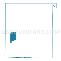
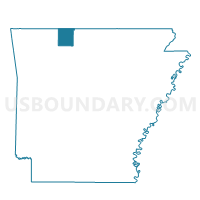
Batavia Voting District, Boone County, Arkansas
About
Outline

Summary
| Unique Area Identifier | 526008 |
| Name | Batavia Voting District |
| County | Boone County |
| State | Arkansas |
| Area (square miles) | 10.68 |
| Land Area (square miles) | 10.66 |
| Water Area (square miles) | 0.03 |
| % of Land Area | 99.75 |
| % of Water Area | 0.25 |
| Latitude of the Internal Point | 36.26081690 |
| Longtitude of the Internal Point | -93.23540240 |
Maps

Graphs
Select a template below for downloading or customizing gragh for Batavia Voting District, Boone County, Arkansas


Neighbors
Neighoring Voting District (by Name) Neighboring Voting District on the Map
- Bryan Voting District, Boone County, AR
- Carrollton Voting District, Boone County, AR
- Jackson Voting District, Boone County, AR
- Summit Voting District, Boone County, AR
Top 10 Neighboring County Subdivision (by Population) Neighboring County Subdivision on the Map
- Jackson township, Boone County, AR (1,340)
- Bryan township, Boone County, AR (1,018)
- Batavia township, Boone County, AR (911)
- Carrollton township, Boone County, AR (843)
- Summit township, Boone County, AR (556)